

Shaping the Future of Carbon Markets with Cutting-Edge Science.
Sylvera’s leverages cutting edge data collection, AI and machine learning to drive transparency and standardization of carbon markets, for a future where the alignment between forest conservation and carbon finance is more accurate and impactful.
.avif)


How we are shifting carbon accounting with high-quality data.

Environmental monitoring has a training data problem.

Despite recent innovation, nobody is able to measure natural carbon sequestration at a global scale with high accuracy today. Satellites and the large datasets they collect have created a wealth of climate information, and with the help of AI we can process it at record speed.
But satellites cannot directly measure carbon stocks like vegetation and soil - their signals can only be correlated with it. To do this well, we need to train models that predict carbon values based on high-quality accurate carbon data. The problem? This data did not exist.
- Data-sharing and academic collaboration
- Hardware provision; enabling ongoing environmental monitoring
- Training (forest inventory; terrestrial lidar; below-ground measurements, and data analysis)
- Computational resourcing and data processing
We’ve pioneered the world’s most accurate measurements of above-ground biomass for forests.

We discovered two critical facts: carbon stocks have been significantly underestimated, and emissions from forest loss and degradation may be greater than what was previously thought.
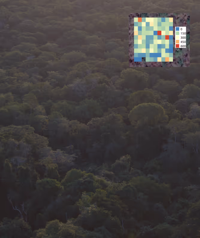
Sylvera research has developed and tested an approach that collects over 450 billion data points across 500km2 using three scales of LiDAR.
This produces high quality training data representative of an entire biome that can be used to remotely measure carbon for large portions of continents.
Pioneering methods for soil.

Soil is a highly significant store of Carbon, yet it's often ignored carbon store due to high measurement costs.
We use a combination of both gold-standard physical sampling and novel scanning methods to measure soil organic carbon.
Sylvera's methods are pioneering increased soil carbon prediction accuracy and reducing uncertainty when compared to existing methods, with emphasis on scalability.
Applications include project assessment and optimisation in regenerative agriculture, forest, peat and wetland.
Three scales of LiDAR for advanced carbon measurements

We discovered two critical facts: carbon stocks have been significantly underestimated, and emissions from forest loss and degradation may be greater than what was previously thought. Sylvera's research has developed and tested an approach that collects over 450 billion data points across 500km2 using three scales of LiDAR.
This produces high quality training data representative of an entire biome that can be used to remotely measure carbon for large portions of continents.
The world's most accurate biomass data - now available via API
30m resolution biomass and canopy height for any location, 2000–present. API delivery replaces months of plot sampling with validated data backed by $10M+ in LiDAR research.
Global coverage with standardized formats means every new project uses the same proven methodology. Expand across regions instantly—no new field teams or data pipelines required
Peer-reviewed science and third-party validation give investors, auditors, and offtakers the assurance they need. Meet next-generation registry requirements before they're mandatory.
Committed to long-lasting relationships with governmental and academic institutions worldwide.

At each step, we engage with relevant local stakeholders to maximize benefits from the data, and ensure these are provided to government entities and local academic institutions. All to enable future expansion of this work, including:
- Data-sharing and academic collaboration
- Hardware provision; enabling ongoing environmental monitoring
- Training (forest inventory; terrestrial lidar; below-ground measurements, and data analysis)
- Computational resourcing and data processing
- Increased transparency and accuracy in the carbon markets
- Decreased risk for investors
- Easier processes for jurisdictions and governments to benefit from climate finance schemes
- Closer alignment between results and project profitability

Explore the map to see where we’ve been, and where we’re planning on sampling next.
Impact Case Study: 13x accuracy, +>50% Carbon in Miombo woodlands.

In 2022, we partnered with the World Bank and Government of Mozambique through the Monitoring, Reporting, and Verification Unit of the National Fund for Sustainable Development.
We produced a 50,000-hectare map of the above-ground carbon stocks across Miombo woodlands, using multi-scale lidar and machine learning for unprecendented accuracy.
The data collection completed was equivalent to scanning seventy thousand football pitches.

Our measurement system is underpinned by methods that are up to 13 times more accurate than conventional methodologies. Using these methods, we found classical approaches significantly underestimated the carbon stock of the sampled area. This was greatest for large trees (those above 40 cm in diameter), which only represent 10% of all trees in the study area by number yet make up 50% of the total carbon stock.

These findings will calibrate a state-of-the-art monitoring, reporting, and verification (MRV) system over the subtropical forests of Zambezia province and demonstrate that these forests are more valuable as carbon stores than previously thought. This ground-breaking research has also been published in Communications Earth & Environment.
Miombo Case: How we collected the data.

Terrestrial laser scans were collected from six 1-hectare plots, providing high-density point clouds describing tree structure down to individual leaves.

Individual trees were segmented from these point clouds, and their woody structure modeled using cylinders, enabling whole-tree volume estimation.
These volumes were combined with species information from conventional inventory measurements, to generate highly-accurate 10m resolution above-ground maps.

To upscale our measurements, we collected 2,000 hectares of slow-flying and 50,000 hectares of fast-flying airborne lidar data, at different heights above the canopy.

We extracted various independent metrics from our airborne data, including canopy height maps, terrain, and forest structure…

…and used machine learning and our 1-hectare above-ground biomass maps as training data to upscale our estimates to six 300 hectare areas, and again to span an incredible 50,000 hectares of miombo woodland.

Finally, we used proprietary machine learning methods, applied to satellite data, to unlock full coverage over the entire province of Zambezia.
Meet our research leadership.

Head of Field Data Science
Andrew heads Sylvera’s Field Data Science team. A remote sensing scientist and tropical forest ecologist, he has helped to pioneer lidar-based methods for measuring forest structure and biomass.

Sophia is responsible for the fundraising and scaling of field research. She has a background in building global, open-source datasets for humanitarian advocacy and action in the UN system.

Miro has a PhD focused on reducing uncertainties in terrestrial lidar-derived estimates of above-ground biomass and processes our lidar data at Sylvera. He brings experience in bio-engineering and nature management.

Pedro has a PhD in Physical Geography, his research focuses on analyzing forest carbon dynamics using remote sensing technology. He has been a co-investigator on high-impact projects such as the ESA Biomass Climate Change Initiative (CCI+), the NERC-NCEO Carbon Cycle: Land, Atmosphere & Oceans Programme, and the UK Space Agency Forests 2020.
Beisit is the Field Science Lead at Sylvera, driving the acquisition of high-integrity carbon data and Multi-scale LiDAR Validation (TLS/ALS) across complex global ecosystems. With 15+ years of experience, she specialises in leading complex, multi-border field missions and mastering the logistics and team security management required for data veracity. Beisit is a biologist from Universidad Nacional de San Antonio Abad del Cusco (UNSAAC).
Discover relevant publications featuring the contributions of our team to academic literature.


Research to underpin the most trusted ratings and partner for project finance
Sylvera uses advanced LiDAR technology combined with satellite data and machine learning to provide accurate carbon data measurements. Unlike traditional methods that rely on allometric models (which can underestimate biomass, especially in larger trees), Sylvera’s terrestrial LiDAR technology provides highly precise biomass estimates. This revolutionary approach removes biases and improves the accuracy of carbon sequestration data.
Allometric models estimate tree biomass based on measurements like diameter and height. However, they are often based on a limited sample size (e.g., the Chave 2015 model uses only 4,004 trees). This leads to undervaluation of large trees and inaccurate carbon estimates. Sylvera’s use of LiDAR technology eliminates these limitations, offering a more accurate, scalable solution.
LiDAR (Light Detection and Ranging) uses laser pulses to create detailed 3D maps of forests. Sylvera specializes in terrestrial LiDAR, which collects up to 150,000 data points per square meter, delivering highly precise biomass estimates. This method is independent of allometric models and provides the most accurate data available today for estimating forest carbon stocks. Sylvera also combines multi-scale LiDAR from satellites and drones to cover vast landscapes with high-resolution data.
Accurate carbon data is critical for ensuring that climate finance is directed toward high-impact projects. Traditional methods often lead to underestimated carbon stocks, allowing bad actors to game the system. Sylvera’s high-resolution LiDAR data provides transparent, accurate carbon measurements that help ensure climate finance supports the most effective nature-based solutions, increasing trust in carbon markets and improving investment outcomes.
Sylvera’s technology is highly scalable, thanks to the combination of terrestrial LiDAR, satellite data, and machine learning. In 2022, Sylvera produced a 50,000-hectare above-ground biomass map of Miombo woodlands, demonstrating the ability to scale measurements across entire ecosystems. This scalability allows Sylvera to provide jurisdiction-wide carbon data for governments, investors, and project developers across the globe.
Unlike traditional allometric models, which are based on limited sample sizes and can undervalue large trees, Sylvera’s terrestrial LiDAR technology provides an independent, unbiased estimate of forest biomass. It captures data at a much higher resolution, allowing for more precise carbon estimates, which are crucial for accurate carbon market reporting and forest conservation strategies.
Machine learning allows Sylvera to process vast amounts of data collected through LiDAR and satellite observations. By analyzing patterns in the data, machine learning models help refine biomass estimates and improve the accuracy of carbon data over time. This advanced technology makes Sylvera’s solution not only precise but also scalable across large regions.
Sylvera provides high-quality carbon data that ensures transparency in carbon markets. This data is critical for governments, investors, and project developers to make informed decisions about forest conservation efforts. Sylvera's approach enables nature-based solutions to receive the funding and support they need by providing accurate, jurisdiction-wide carbon estimates.
The Global Carbon Mapping Project is Sylvera’s initiative to create accurate, large-scale carbon data for forests around the world. Using multi-scale LiDAR, Sylvera produced a 50,000-hectare above-ground biomass map in Mozambique, setting a new standard for jurisdiction-wide carbon monitoring. This project showcases how Sylvera’s technology can revolutionize carbon measurement on a global scale, supporting climate action at every level.
Accurate carbon data, like that provided by Sylvera’s LiDAR-based technology, ensures that climate finance is directed to projects with the most significant impact. By eliminating biases in carbon measurement, Sylvera helps investors identify projects that truly contribute to carbon sequestration, driving more funds toward nature-based solutions. This increases transparency in the carbon markets, builds investor confidence, and supports global climate goals.
.avif)
.avif)

